
heat up when air is lighter than the air around, rooms. As a hill ascending, thermal upward is controlled by a number of variable factors, indeed, by a huge number of variables.
Drivers who prefer flights in thermal lift than cite the following reasons:
thermal offer flights with more options, since they can occur in a wide range of locations;
entail more challenges since the thermals are less predictable than the lift and require greater skill to find them;
perhaps the best of all, thermal can take you to great heights.
If you find a good thermal, try to climb as high as possible, considering a long flight (cross-country).
Causing force
The force behind the phenomenon is the thermal solar energy.
As regards the sun heats the earth surface and this heats the air around, some surface components heat up more quickly than others : a sandy area warms faster than a forest, for example.
Generally, Warm air is lighter than cold air. however, moisture its role is also, since moist air is to 2% lighter than the dry air.
The rule, then is this: A mass of air is hotter and / or humid air than the shrouded, this mass is lighter than the surrounding.
O Initial Impulse: TRIGGER
If the air mass is sufficiently lighter than the one in back, she eventually separates from the surface and rises. This initial movement creates turbulence on the surface with the heaviest air filling the place of the lighter that is rising.

Convection
Once soil detaches, thermal begins to expand as it climbs. Continues to rise while its density is less than the air around. His ascension ratio is dictated by how light it is. With the thermal expanding and cooling, his ascent rate decreases.
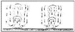
Once the air rises have to be reset. The air that is denser around the thermal falls. This circular flow forms a small scale of a convective system.
The thermal occupies only a small portion of convection given area. Most consists of descendants. The greater the distance of the thermal, lower air rate of descent.
Dissolution
Eventually the thermal is one of many possible destinations and ends. It can be blown by winds, dissipating the, it can become a cloud and then dissipate, or it may simply be extinguished as expands, cools and mixes with the surrounding air.
Factors Affecting Formation of Thermal
How very strict standard, just the sunlight in a dry soil for 20 minutes will be enough to form a thermal potential - a mass of air that is lighter than the surrounding.
The sun warms the earth not uniformly result in numerous exceptions to the rule of "20 minutes," .
Angle of the Sun in contact surface
The angle at which the sun hits the ground is a large role in how much heat will absorb surface. The sun angle in a particular area varies with latitude, the station and the time of day.
Besides that, variations in the ground contour imply individualization of the land components that receive more solar heat than others. Land that receive sunlight directly absorb more energy than those who receive this light with some inclination or failure fashion.
A hill with his face to the east for example, It is able to generate potential thermal morning, It has similar efficiency at noon and probably not good afternoon.
Land Features
Some soils are more inherent heat absorption than other:
generally, dark surfaces absorb heat while the lighter reflect.
flat surfaces that absorb more rugged terrains.
bare land heats up faster than covered with vegetation, part due to the wet plant transpiration which cools the air. However the vegetation retains heat longer than bare soil.
dry areas heat up more quickly than wet, because part of solar energy is used to evaporate the water that is in the most humid area. Besides that, heat is stored in water, which is conducted to the deep areas, distancing itself from the surface.
In other words, thermal are easier to develop over a pile of rocks than on the vegetation that surrounds it; more about the beach sand than on a nearby lake; e, more about a clean campus on a full bushes (until the end of the day, when the situation is reversed and upside are best located on vegetation due to its superior heat retention).
Urban areas contain smooth and dark surfaces such as streets and parking areas, activity that generate heat (ovens, etc..), towns and cities often generate heat. Naturally, sufficient and extreme caution is required altitudes when flying over inhabited areas.
Obstruction of sun rays
Anything that inhibits the sun's rays touch a surface, inhibit your heating.

natural obstacles: clouds, mists, Dust or mist. Man contributes smoke, soot and pollution. Characteristics of surfaces that are higher than the ground beside - mountains, trees, buildings, or other structures - generate shadows indicating areas where the sunlight was blocked.
If the obstruction is complete, as a cover of a heavy cloud, heating the surface is reduced. partial blockage, otherwise, can facilitate the development of thermal as uneven heating facilitates the occurrence of thermal.
winds
In some cases, the wind prevents the formation of thermal, because the surface cools and mixes the air. In other situations, can help.
As the wind cools the surface, areas that are protected can continue absorbing heat, may result in differential temperature sufficient to generate thermal. Fields with dry grains, mowed areas and protected areas descent winds are excellent sources of thermal winds in conditions.
Factors Affecting the trigger
A slight air accumulated thermal mass is not itself. It needs a trigger to be transformed into a thermal.
The trigger can be compared to that which occurs when condensation accumulates in a pipe. The moisture may adhere to the tube indefinitely, but if you touch the barrel with your fingers, breaking the surface tension that is retaining the moisture in the tube and the water begins to drip. Then, the surface tension begins to break down as a chain reaction across the surface, causing dripping on the original contact point.
In a similar model, a gentle push, can, sometimes elicit a high thermal. Wide variety of forces may initiate a thermal.
Local Trigger
Some trigger involve local contrasts in elevation: hill crest, mountain peaks, slopes of edges, cliffs… .
Others involve temperature contrasts: or topo forest, plowed fields, lagos, or humid areas.
With the Air Movement
Most likely, the most common type of trigger occurs with the wind or other air moving. This fact explains why the trigger does not necessarily occur - and most often does not occur - in the same place the original heating the air mass.
For example, a light air mass formed on top of a plateau and then pushed by a breeze will be able to climb free so that it reaches the crest of the hill.
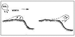
When the wind is soft and therefore less able to by itself trigger a thermal, a trigger location becomes very important and will be easier to take place far from where the original was heating the air mass.
When searching for thermal in days of light winds, pay more attention to trigger points than space heating.
Most thermal any assistance is initiated by wind or other air moving (strong descendants are great w / it).
The wind can act as a trigger for himself, simply giving a "blow" in a thermal potential. Anything that makes the air move - a car traveling on a road, a plane taking off, a moving train, another stray heat that is nearby - can have the same effect.
triggers Independent
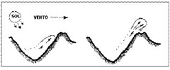
A trigger location can sometimes start a heat that is released, even without the aid of air movement. For example, a place involving large temperature contrasts - the edge of a lake, a river, tussock, … - sometimes result in a mass of air that is significantly lighter than the air around. air masses as they can by themselves be the trigger, or else, requires a weaker thrust than in other conditions.
Another example: a hot air mass heated in a valley between mountains and then flowing into these top, can be released as a thermal ground as soon reaches the crest of the hill.
Local temperatures Extreme
Extremely high temperatures, from sources other than the sun, found in a particular area, It is a kind of heat where the heat itself eliminates the need for any additional trigger.
Fire
Fire burned or manmade or natural origin, generate upward air masses. Unfortunately, in this case also appear contrary movements like oxygen descent that will feed the fire, resulting in turbulence and violent offspring.
Although not recommend that fly over the fire. I have to report that some drivers have done this, despite the danger posed by turbulence and the possibility of being swallowed into the fire and the flames.
Factories thermals
very large plants sometimes produce useful thermal… If you decide to fly in a heat generated by an industry, be aware that in addition to soot, smoke, dirt and unpleasant odors, some industries emit toxic gases. Besides that, They are often very turbulent.
Characteristics of Thermal
Thermal have been compared to snowflakes where one is never equal to another. There is however some general structural thermal. An understanding of the variables which create and form these basic structures can help the driver make the most.
Size
This is perhaps the simplest of variables involving the structure of a thermal. The size of the original air mass (heat or moisture source region) the initial impulse and determining the approximate diameter and shape of the resulting thermal.
The heat can be 1 up to hundreds of meters in diameter. To be useful to the free flight, should have a thermal around 30 m (Flying 10m / s = 36 km/h, travels up this distance 3 seconds) no minimum.
Duration of Heating
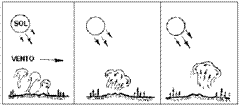
The frequency of heating a given surface - that is, constant or intermittent - determines the overall structure of the vertical thermal. The two basic structures are the columns and bubbles.
columns
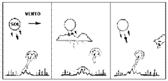
If an area receives constant heating, is able to produce a column
stable of hot air rising from the ground: "a thermal column". This is the most common type.
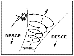
The strongest rise is found at the center because the peripheral air has its speed reduced by friction. When air in the center column reaches the top of the thermal, The rising air expands, and down the sides of the thermal, part of this, returning to the ascending column.
If solar heating is stopped, as the passage of a cloud, thermal activity can be interrupted (sometimes nothing happens) cutting the column. The result is a heat column segment. When the heating back, Thermal activity is reactivated.
bubbles
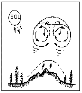
If heating is intermittent or generally weak, a "bubble" light air can be released and forced up, with the heaviest air coming to replace. After a time - a few minutes, an hour or more, depending on the speed at which the surface is heated - another bubble is released.

theoretically, a bubble has the shape of a circular whirl - as a smoke bubble - with a strong rise in its center and low ascending or descending at its edges. Keep in mind that almost every discussion about the form of heat is based on theory. It is complicated and expensive measure. To view, impossible with the techniques known at present.
Frequency Trigger
If the thermals are often driven by strong winds, They tend to be small and weak.
drift
The wind also influences the course that takes a thermal, so it rises. The thermal columns lean and break winds with varying degrees in accordance with the strength and wind direction versus the upward force.
Because they are "connected" to ground the thermal columns tend to adhere to soil, resisting the inclination and displacement for a certain time.
If the thermal bubbles, segments thermal columns, and thermal columns are separated from soil, become more likely to be displaced by wind.

Thermal with Multiple Centers
The wind action can generate heat with multiple centers. The wind can blow gentle heat for a strong trigger point, coalescem wave (crowd, similar approach of a drop of water with other).
Similarly, Air movements arising due to thermal, Thermal can start another nearby and then unite, forming a thermal centers with multiple single.
Dissipation
If the wind is stronger than the heat it can dissolve the thermal literally blowing it to pieces. above winds 40 km/h (always approximate numbers) They are strong enough to dissolve most (not all) thermal.
Cloud Street (What district ?, second Caveirinha)
good areas for the production of thermal can generate a thermal queue called "Cloud Street".
The direction of alignment of this line depends on the wind direction and terrain.
Form over a mountain range, a river, great contrasts such as sea / sand,..etc, usually follows the relief. In the absence of major obstacles, formed aligned with the wind.
A "Cloud Street" allows flight without turns throughout its length with only occasional circles. The rising air columns are separated by a distance of approximately two and a half times the height of the thermal. The air descending, ranging from mild to strong thermal `proportion of force occurs between the columns.
To form such routes the wind must blow in the same direction through the convective layer (in which the layer is formed and heat up) preferably increasing the speed with altitude.
shear
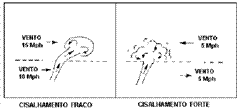
Two layers of air blowing winds involving adjacent directions or at different speeds, is the shear.
When a thermal shear is, tilt-is, it is dragged, or is scrapped, It depends on the relative strength between the layers and the thermal. Generally, shear involving wind speeds difference 15 km / h is enough to completely dissipate thermal.
Stability
Normally the air temperature drops with altitude. If this decay is steeper than normal (Normal refers to adiabatic expansion), this is, If the atmosphere is colder, said atmosphere is unstable and promotes w / occurrence of thermal. Otherwise, it is said STABLE and convective movements are less frequent.
Thermal rate of climb
The temperature increase of charge - ie, his strength - increases with the degree of instability. Greater instability, the higher the temperature contrast, together with the effect of moisture, determines how fast a thermal climbs. This is, a thermal generally rises faster in those altitudes where the temperature decreases rapidly (higher thermal gradient).
When the upper air is much colder and heavier than air current altitude, it effectively "draws" thermal for faster up.
When pilots talk about rate of climb, They want to say about the reason which gain altitude on an upward, instead of talking about the reason which the air is rising. So when drivers talk about "thermal 2 m/s” (1 m/s = 200fpm ; fpm significa: feet per minute), They mean that rise at a rate of 2 m/s ; heat alone is probably rising at a rate around 3 m/s, since the common drop rate in equip. Flying is 1m / s.
this text (as is usual among pilots), the rate of climb and descent (sink rate) It is referring to the pilot rises or falls.
There are upward of records over 20 m/s, usually, under very great clouds mainly in the vertical size.
Height of Thermal
The height of the unstable layer (Convective) usually determines how loud a thermal will. A thermal usually continues to rise until it encounters a strong enough inversion layer. No deserto de Mohave, thermal typically reach of 3.000 at 4.500 m; no Owens Valley, reach of 5.000 at 6.500 m. There thermal reaching the stratosphere, usually forming CB's that depending on the latitude can reach around 25.000 m. Most of the heat used to fly reach altitudes in the range of 1.000 at 2.500 m.
Thermal inversions
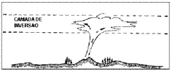
Inversion occurs when the air temperature increases with altitude instead of decreasing. The inversion can reduce or stop the rise of a thermal, depending on the thermal strength and size of the inversion. It tends to cover the lower layer, It can be seen from above as a mist or a layer of "soot" clear air below. The associated shear, usually generates wind gusts and turbulence horizontal.
Thermal Dissipation
The fate of some thermal can be observed from the ground, since many thermal take the form of clouds before finally dissipate and disappear. Other thermal - known as "blue thermals" (thermal blue)- disappear before they become visible.
Disruption
Some thermal are simply blown by strong winds or separated
by severe shear.
Stratocumulus clouds
An inversion can interrupt a thermal if stronger than the thermal. Turbulence encountered due to shearing at the base of the inversion layer, They tend to brake thermal and dissipate its heat through this layer.
Over time, the inversion layer becomes progressively thicker and the maximum height decreases thermal.
Estratocumulus type clouds are formed in the inversion layers have enough thermal humidity. As this cloud layer becomes thicker heating surface tapers. Eventually the thermal activity ceases completely.
These conditions, described as "super development" can persist for hours until the clouds will eventually be dispelled by the sun's heat and / or wind, or the lowering of water to hotter regions so that it will return to evaporate.
If not dispelled by wind or interrupted by a strong inversion layer, Thermal a wet end normally in the form of a cloud, which will eventually dissipates.
Cumulus
These are the most common clouds formed by thermal. Several steps are involved in its development.
As a thermal climbs, it cools. When the water vapor contained in the heat is cooled to its "dew point" it condenses, forming droplets to reflect light displaying in white. These are the most common clouds formed by thermal. Several steps are involved in its development.
As a thermal climbs, it cools. When the water vapor contained in the heat is cooled to its "dew point" it condenses, forming droplets to reflect light displaying in white.
The condensation process releases energy which is added to the upward generating turbulence within cloud. The sudden increase in the rate of rise causes thermal blends quickly with the surrounding air diluting the slightest rising air. This sudden dilution of rising air and condensing water vapor are combined so that the cloud enters a dynamic balance, giving the impression that it is stationary (sometimes it is even).
If more thermal continue to feed her, the cloud continues to grow. Cumulus clouds typically reach altitudes 800 a. 5.000 m.
The first suspended droplets form irregular lint that will become thicker and coalesce. The cloud is becoming increasingly more compact and their sharper edges. A dome formation (concave) appears above the strongest rise area.
Droplets floating below the cloud also indicate humidity and strong rise. The best rise area is usually on the side the wind comes (upwind), especially if you receive additional heat from the sun.
When the thermal ends (perhaps because the cloud has blocked the incidence of heat source), the cloud enters its final stage. The base becomes convex and the edges begin to crumble. Cloud contours become less defined.
The remaining fragments cloud dissipate in offspring, that persist for a short period of time after all visible traces of the cloud have disappeared.
The drier the air, faster this process occurs. Numerous clouds in an area indicates the surrounding air humidity is high prolonging life (w / me they, as well as the atmosphere, they have life) the clouds.
stratocumulus
If the air above the base of a cloud type Cumulus is damp, The rising air can initiate a chain relationship. The result is the condensation of moisture surrounding. This process continues while the air continue condensing, This can happen even with the thermal ceased.
If the wet layer is accompanied by a reversal (as they often are), the cloud can flatten and extend laterally, forming a Stratocumulus.
Cumulonimbus
Cumulus clouds of the type sometimes become in a cumulonimbus clouds (or "Cb"), which continues to grow, even if the original is finished thermal, reaching heights above the 12.000 m (It depends on the latitude). The top of Cb's usually reaches the Troposphere.
A Cb is formed when there is a strong heat source, unstable and moist air, and no strong inversion that will stop their growth. very strong winds usually prevent the formation of Cb's.
The energy released by thermal condensation is added so that from a certain size, this energy condensation becomes sufficient p / promote cloud growth. The higher your size, greater energy release and the faster growth. The cloud becomes larger and more complex, may contain multiple centers with up strong and turbulent descendants, and usually violent.
Cb's are clouds that can cause many problems to any type of aircraft. His influence can be felt over 60 km away.
One of the serious problems that occur in this type of cloud is the fact that the pilot to be away imagine being in safe distance from its vertical action, however the risk exists not only in being "sucked". When the rain begins, the water that falls in incredible volume, pushes the air is low and that it reaches a speed exceeding 100 km / h in places that at first
They seemed protected from its effects.
Do not rely on the fact of being white cloud as if you are on the side that the sun shines, you verá branca. Even very small clouds appear dark when there is shade them.
Generally when the day is suitable w / Cb form a, is p / form other and a much larger cloud can be hidden by a Cb your experience is to be safe.
Unfortunately, We had several world champions in practice flight (gliders and hang gliding), as well as other very competent drivers, they were wrong to imagine the damage of such clouds and had no opportunity.
Avoid Cb's:
"Cb in the air, flying(a.) no bar!”
Expansion, admixtures, Cooling
Thus soaring, a thermal expands. While expands the growing friction dissipates part of the climb power. It also occurs with the surrounding air mixture, gradually dying out.
If the thermal lack sufficient moisture to form clouds, it simply rises, without however becoming visible (blue thermal).
Choosing the Best Time for Taking Off
First, you have to choose the appropriate time to take off. After, must locate the thermal. And finally, get the best out of it.
Also as in the lift, set the time to take off begins with the observation of the moving vegetation, notice the wave vegetation up the hill.
when you take off, do not expect the heat is developed on the ramp.
Take off at the beginning of it. Os timing cycles (time interval, and) help them set the most appropriate moment.
Watch the birds, cloud formations, etc… It is important that the other signs are indicating a time to rise.
Finding Thermal
Use your knowledge of thermal, their thinking and all available evidence to find the thermals, which will help you achieve your goals flight.
Lay out your learning and experience to locate thermal. What do you understand about the process of formation, They are structured as, triggers, how they develop as they go up, as extinguished and estimate where the heat is likely to be located.
Ask yourself : where the warm air must be?
Where are the trigger points? (remember that the points of triggers are so important how many heat sources, especially in light winds).
How the air is moist?
If you are moving?
How fast?
In which direction?
Your questions and a little logic will increase the probability of finding a thermal (or be found by a).
Whenever you are in a thermal, try to identify where it should be going out. If you're able to locate the source, note its position in relation to it, checking how is your drift. Note that it typically changes with altitude. Use this information p / similar conditions.

Visible signs
Sometimes you will see signs that either confirm or contradict his conclusions.
For example, if spotting dust, flag or smoke different points converging to one, rather than drift with the wind, the air must be rising from that point. Instead, if these signs show that the winds diverge from a single point, there is a possibility that the air is above down.
In areas with vegetation at the sight of leaves moving independently of any wind, may indicate a thermal releasing it (unfortunately, you have to be down to see the movement in the vegetation).
Fog Summit - Top formations in the inversion layer - are generated by thermal trying to pierce the inversion. You will be able to see more easily through fog sunglasses with brown or yellow lenses than with blue lenses. The Polaroid lenses are the best ; you may see fog, clouds contours, dust more easily through polaroid than with naked eyes.
More About Clouds
Cumulus clouds are a big clue indicating the existence of upward, however there is a significant time lag between the development of a thermal and development of Cumulus cloud it produces.
If you are a certain distance from a group of clouds, choose the smaller one with the clearest base, you are growing. If you are high enough, select the cloud with its most well-formed dome. Lower, select the cloud with the darkest area at its base. In your choice to realize that the cloud base is becoming convex, It means you are dissipating.
Some signals are concrete evidence is where thermal, not only where I could be. strong thermal load, sheets, insects, dust, plastic bags, etc.
Dust Devils
The air pressure is much lower in the center of a "dust" and a strong turbulence may exist throughout this center wall, especially near the ground.
The "dust" is formed from the meeting of two or more thermal. The region is rising around them and not about. not inside, there is strong downward.
Another visual indicator is the smoke. Stay tuned, for if smoke always rise with the thermal, we would not have pollution problems so severe. Their behavior is that it must be analyzed.
When you catch sight of it suddenly drifting p / up, It is thermal signal.
Generally the solid particles which form what is called smoke, with the wind so that the main part of the heat is usually a little more against the wind. cement industries fumes are much heavier than the other, deriving much for it, which sometimes gives us the false impression very strong wind.
Finally, if sight gliders, foundation, parapentes, Birds are not flapping its wings, circulating and gaining altitude, there is no doubt that there's a thermal.
Birds can use thermals that are too small. When used in combination with other methods to estimate the size of the thermal, the birds make excellent thermal sizing, Yet, sometimes birds are just playing (at least it seems that). Important to make sure that they are actually rising.
Assessing the size and strength of the Thermal
Suppose you find a thermal, but have no idea of its width or its strength.
Keep flying ahead and stay tuned to your vario. If the vario continue recording the rise as you count slowly to three, start or rotation. Do not follow it rigidly.
If you are unsure p / which side, make the turn into the wind, because if the wrong direction, You can still hold the heat. Turn pro and am wrong, fall in the descending and then against the wind will be more difficult to return. From then, go doing ellipses, in order to map better thermal.
Important to remember that you should always bend at maximum up point. Ever After vario have stopped beeping. This rule helps a lot in the beginning. With time and experience, each rider will adapt p / a method.
If there are other pilots, rotate w / the same side of those who were there already.
In thermal, focus on staying on the rising mais.Tente position yourself so that the middle of this is at the center of their rounds.
There are numerous methods to center thermal. They always seem easy on paper, but not so much to put into practice in the air. My method is to simply keep turning, varying or two laps center, increasing or decreasing the curvature whenever you suspect there is a better up at another point.
If you are flying with a thermal wind, will move the circle against the wind, it can be pushed by the wind and fall into the downward.
If Losing it …
Fall of a thermal is a fairly common experience. If you can not find the heat after falling from her, it may be that she has separated and risen up from its altitude. Or, It may have been dragged by the wind; sometimes, You can find it by turning to the wind, but make sure before that it is not in the opposite direction to the wind.
Fast upload
To climb faster you have to be in the region that rises more. The stronger upward at the center of a thermal, soon it would be logical to fly in the smallest possible radius to be as close to the center. However, narrow turns mean angles to the horizontal increased, and hence greater rate of descent. If the center of the thermal is significantly stronger than the rest of the thermal, Small radius curves are warranted. If the difference in the rate of rise heat is less drastic, fly at higher spins to get a lower rate of descent of your equipment.
Each has its thermal characteristics. Try to observe birds and / or other drivers as a reference. Experiment and use the vario p / draw their own conclusions. Having a mental picture of what happens is fundamental.
Take care com Hypoxia em High Altitude (for those who come into monstrous clouds, beyond the cold …)
If you are too high, conserve oxygen to make only the necessary movements; you need oxygen to warm. Take care turned to Hypoxia, a condition resulting from insufficient amount of oxygen
Always Have a landing area in Mind
Once you are in the air, be sure that a landing area of some sort is within their plans.
Consider that to achieve this landing area must rely on the performance of your equipment, with the wind direction to help or hinder achieving this landing and any descendants who can find the way.
Leaving A Thermal
Before leaving a thermal has a plan for your next step, do not expect to get to the base of a cloud to chart a new plan of where to go next. Review the surrounding clouds as you go up, using the time spent in turns to determine which one is developing and what is dissipating.
Some riders simply leave the heat when they are aligned in the direction of the desired target.
Other riders prefer to leave the side p / escape strong downward or turbulent situations.
Always it depends on the heat in question and the position in which it is, what works best.
Leaving the core, or even to align in the desired direction may have more turbulence.
Whatever the technique, be prepared to increase its speed when descending through the air exists outside the thermal, through as quickly as possible.
It may also be prepared to traverse the interfaces that may have severe turbulence when the vertical velocity gradients are large.

Some Etiquette:
If you go into a thermal already occupied by another pilot, rotate in the same direction that the pilot.
Adjust your turns so that they are concentric with the other pilots.
If another driver is going up faster than you and is below, give priority, as the pilot of this vision is more limited than his.
The concept of other rules applied to sites in particular are valid for both flights on slopes and in thermal. Check with local pilots to the specifications.
Flying In Other Types of Ascending
There are several types of ascending beyond lift, and thermal waves. This section will discuss some of these other, especially those most appropriate to gliding. It will not be talked about types as dynamic glide, the technique which allows the flying ace, albatross, make trans-oceanic flight taking advantage of the wind horizontal gradient. This technique requires high performance levels beyond what is possible to paraglide and hang. Possible only w / some gliders. Same for wave flight as p / it is necessary that the equipment is fast (above 100 km/h).
Pre- Frontal
climate cold fronts can provide transitional ascending which can be used for free flight pilots in certain situations.
How fronts are Ascending Maids
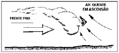
Upward facing occur when a cold air mass is a mass of hot air and the upward force.
slow fronts produce weak ascending, fronts moving quickly produce strong upward. cold fronts (Cold air advancing into the hot air) They are generally more inclined and faster than warm fronts (Advanced hot air from the cold air) and usually produce strong upward. If the hot air contains enough moisture to condensation, the approach of a cold front may produce clouds Cumulus type or Cb's.
These sometimes cumulus clouds form a solid wall between 50 – 150km ahead of the cold air mass.
There is possibility of strong currents in these wind conditions can change any existing wind 180 degrees…very fast.
As Fly Pedigree Fronts
To fly in the approach of cold fronts should be positioned ahead of the clouds, however this practice is extremely dangerous, because there is possibility of CB's training and very strong winds, which can greatly harm the landing.
The best area of the rise is below the leading edge of the cloud above the front. This area tends to be narrow and is followed by dangerous "sucked" and showers.
The whole phenomenon is moving and you should move along with it in order to avoid being "swallowed" by the winds coming up behind you, regardless of the route he is taking, Whether you want to or not.
Therefore, if you reach the required altitude or already in the air, and if the front direction corresponding with its course, and if you take care to maintain the proper position relative to front, stay up on the front can be a way to fly great distances.
When you fly up in front, it is imperative that you keep your eyes open in the situation. The minute you determine that strong winds and / or turbulence are making their perilous position, skirt.
This decision based on its assessment of conditions or other evidence…
I recommend paragliders do not dare to fly in these conditions.
Convergence
When two air masses in motion are, the point of the meeting is called "convergence". Where a convergence occurs, right amount is forced up. This upward movement is known as "convergence".
Convergence with the Sea Breeze
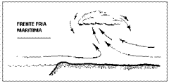
Fronts created by the sea breezes are a special kind of face with characteristics different from those that occurred on land.
These fronts occur when cold air over the sea (cooler than the land during the day) flows into the earth beneath the hot air, forcing hot air onto, which rises and moves towards the sea to complete the convective flow.
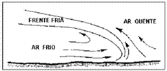
The sea breeze can penetrate inland for more than 100 km when the terrain is flat (Alfredo Chaves in the region, fails to move 5 km sobre a terra) and reach speeds above 40 km/h. Breeze strong sea can inhibit thermal activities in the coastal area, although this area are possible thermal. thermal activities are typically stepped along the main front edge.
Temperature differences
The greater the temperature difference between the water and the land, the greater the convective flow. The coastal areas that flank currents of cold water, They are prone to strong convergence (if the land is sunny).
How to Identify a Sea Breeze Front
The sea breeze fronts usually leave a number of indications where occur.
A voucher Afternoon
When a slope begins to cool after a day of hot sun, The cold air tends to descend the slopes. These winds are called "katabatic".
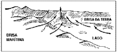
katabatic winds from a single hillside acts as a small cold front, pushing the hot air upwards. If you descend the mountain on both sides of a valley, there is a convergence in the valley.
Oftentimes, a valley offers the best ascending afternoon. Birds flying over a valley in the late afternoon is a good convergence signal katabatic winds. They are likely to hunt insects which are carried upward by the rising air.
In Hot Local and Remote
If an air block is surrounded by cooler air, air moving in all directions and the upward force.
Above Obstacles
When the air moves upwards on both sides of an obstacle such as a mountain or hill, forming a convergence up. This phenomenon is most often the result of winds "anabáticos" that occur when the slope is heated and a thin layer of warm air flows field above, if it occurs in a single slope, we only lift.
This type of convergence tends to be strong and very turbulent (careful when flying over a hill crest). moderate wind causes the area to rise lean; strong wind destroys convergence leaving only lift.
Multiple Sources
The best type of convergence is one that combines strong winds from various directions. Such convergences are found regularly in appropriate locations.

How to Identify a Convergence
If the humidity is sufficiently high, convergence can be marked by small clouds Cumulus. On a cloudless day, look for signs like mist, fumes, Dust converging w / a line. In another way, suddenly find calm air after spending time in a fast air, you may have entered a convergence.
How to Fly in a Convergence
In most cases, it is necessary to climb to reach the thermal convergence areas. Normally, thermal activities are stepped along a convergence line. Once it, just relax and fly for a distance as if in a lift.
Leaning up Convective (Thermal Lift)
It's similar to lift hill, except for the fact that the "hill" in question is a mass of air and not a topographic feature.
How Built
A strong thermal creates a barrier in the air, an obstacle to their movement. Thus, resist being blown by the wind, especially by the fact that the thermal tend to "anchor" n soil. As a hilltop land-based, of the moving air is forced upward into the barrier. Such "thermal lift" exists only for the time that the heat remains cohesive.

The following variables are involved in the formation of this type of lift:
Force Convection : heat must be sufficiently strong to create a barrier.
Wind form : ideally,, the wind speed increases with altitude, allowing heat to develop in mild winds near the ground, Let there be but strong upper winds to create a strong thermal lift. Generally, the stronger the wind, the stronger the upward.
Identifying
To locate this type of ascending, look for large cumulus clouds but still growing, with strong upper winds. When lack sufficient moisture in air to form clouds, there is only one form of location: kind.
how to Fly
Flying these ancestors is as you would in hill lift: with returns and advances in wind and doing away curves of the "mountain". First, However, thermal test to see which is stronger ascending.
This type of upward is very useful when your goal is against the wind.
Anticyclone
um anticyclone (or high pressure center) It is a region where air sinks from above (and heat and is very stable) and suppresses the upward movements necessary to the formation of clouds and precipitation. So good weather (dry and cloudless) It is usually associated with anticyclones: hot and dry in summer and cold in winter with clear skies. The Anticyclones are indicated on a map as 'A' and is a place where the atmospheric pressure is the highest in the vicinity. As the air flows from high pressure centers is deflected by Corilolis force such that winds circulate around it in the direction of the hands of a clock in the Northern Hemisphere (and in the reverse direction in the Southern Hemisphere) – the call towards anticyclonic.
In an anticyclone moving air is descending, spiral, expanding surface, while a depression motion is ascending, spiral, focusing surface.
During the winter, a downward air cyclone can create an inversion temperature, retaining smog during days.
Cyclone
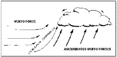
a cyclone (or depression or the center of low pressure) It is a region in which relatively warm air rises and favors the formation of clouds and precipitation. That is why, cloudy weather, rain and strong wind are usually associated with low pressure centers. The instability of the air produces a large vertical development cumuliform clouds associated with loads of water.
Weather maps are displayed in the letter 'B' and are places where atmospheric pressure is lower in the vicinity and around which there is an organized pattern of air circulation. As, by the action of the pressure differential, air flows from the centers of high pressure to low pressure center is deflected by Coriolis force such that winds circulate in a spiral along the isobars, with a deviation in the direction of depression, and the direction cyclonic, this is, clockwise (direction of the hands of a clock)in the Southern Hemisphere and counterclockwise (opposite direction to the hands of a clock) the Northern Hemisphere. In meteorology air movements in opposite directions are called anti-cyclones.
As an example we can mention the cyclone frontal systems, tornadoes and hurricanes. As, India and Australia, hurricanes are called cyclones (e, Asia, typhoons), the media constantly confuse the term cyclone with hurricane. Meteorology differentiates extratropical hurricane. A hurricane is hot core and is formed of hot water, generally above 26 degrees Celsius. Extratropical in general is a phenomenon of middle and high latitudes that arcs to tropical latitudes, commonly associated with cold fronts and baroclinic waves at high levels of the troposphere;
Cyclones are easy to recognize on a map of the surface observations by the winds tend to flow into it with a rotation "spiral" and on satellite images by setting shaped cloud bands comma.
In the northern hemisphere, a cyclone development is typically accompanied (east of the center of low pressure) by a warm front behind which southerly winds carry north the warm, moist air from a hot air mass, contributing to the development of precipitation. Behind the center of low pressure (his West), North winds carry more cold, dry air to the south, with a cold rolled across the front edge of this colder air mass, and dried. In the Southern Hemisphere, or cyclonically as it inverts, It is typically observed in this situation symmetrical.
A Final Thought About Free Flight
The more you know about how the rising work, the more you will be able to locate them and fly them. Increase your reading theoretical knowledge and relates to the phenomena observed in practice.
Even when you are not flying, note the time. Try to get in the habit of being aware of the weather conditions at any time anywhere.
Observe cloud formations and their dissipation. Procure por cloud streets, convergences and birds. Imagine yourself flying these rising, even when they are doing something else.
No need to be in the air to observe the weather.